Lauderdale Yacht Club – Thursday, July 16, 2015
We were in our spot on the Lauderdale Yacht Club’s south wall, tied up and plugged in by noon. But, before we could get fenders in place against the wall, it was raining. We have local boaters option cards which make it a little easier to check in to the U.S. when arriving. All we have to do is call a toll-free number and give them the information that they ask for. We were cleared by Customs around 12:45 – which was about the same time that the thunder storm subsided. Rick went into the office to get us checked in. But showers continued until about 4:00. Rick could get e-mail via the club’s Wi-Fi, but I could not. Also, it appears that our router has quit working. (That’s the thing that allows us to use more than one computer with one internet connection and use our wireless printer.) It worked before the thunder and lightning but didn’t work after that, so Rick thinks it might have been hit by lightning although there is no obvious evidence of it. We went into the club for supper. Their main dining room was occupied by a group (with a lot of children) playing a game that they call YACHT. The hostess told us that it is really BINGO, but they changed the name! She took us back to their lower dining room which has glass on three sides and overlooks the pool patio where they have outside dining and the Intracoastal Waterway. The food was good and we enjoyed the complimentary cookies (especially the macaroons) after dinner. We left the Lauderdale Yacht Club around 8:30 the next morning.
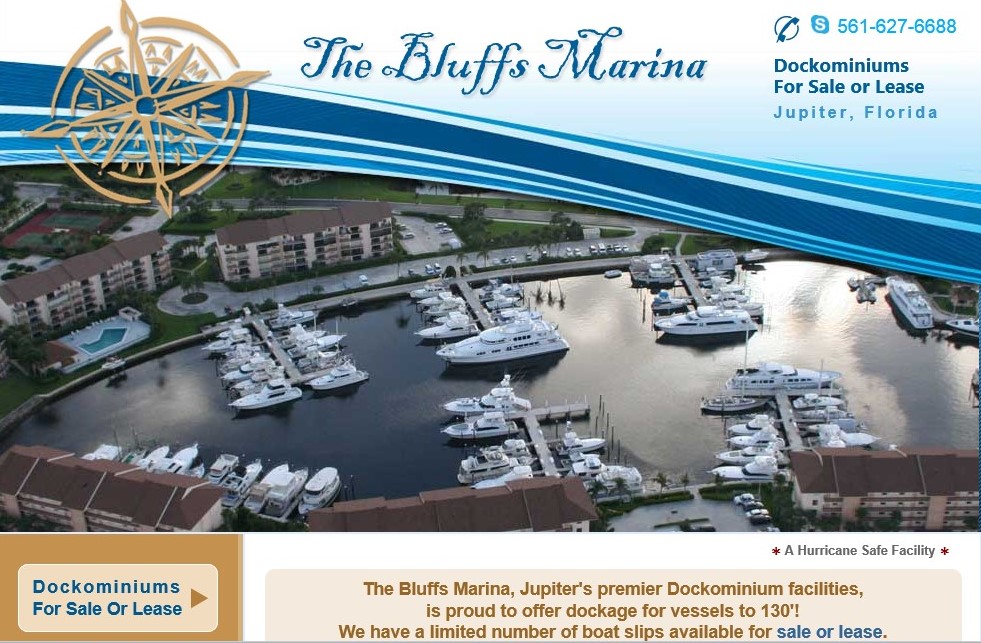
The Bluffs Marina – Jupiter, Florida – Friday, July 17, 2015
Like yesterday’s extremely smooth ride from Bimini to Ft. Lauderdale, the Atlantic Ocean was once again as calm as a lake. The only swells we encountered as we travelled up the coastline were wakes from other boats. By traveling in the Atlantic rather than the Intracoastal Waterway (ICW), we figure we avoided nearly 15 bridges which would have to open for our 30’ height. We came back in at the Palm Beach Inlet. We went under the Blue Heron Bridge which connects Palm Beach to Singer Island; then we had to wait a few minutes for the Parker Bridge to open at 45 minutes past the hour. It was only one mile to the next bridge, the PGA Blvd. Bridge, which opens on the hour by request only. We waited about 10 minutes for that opening. Then we continued north at a no-wake speed about 3 more miles to the Donald Ross Bridge which we were able to go under without an opening. We had met a very nice couple, Bob and Mel, on the boat Istaboa, just before we left Compass Cay. They encouraged us to stay in their slip at The Bluffs Marina in Jupiter. So, after we passed under the Donald Ross Bridge, I gave the marina a call and was welcomed and given directions to their slip. We were docked by 12:45. Rick went to visit with the harbor master while I straightened up. He said that he had a nice long chat with L. J. You can learn more about The Bluffs Marina at www.thebluffsmarina.com
I did a lot of research on the Okeechobee Waterway which we will enter tomorrow heading west across the State of Florida. It looks like we’ll be traveling about 50 miles and will have several bridges to deal with. It started raining around 5 p.m. and continued until after 8 pm. We ate supper on board.
Indian River Marina, Saturday, July 18, 2015
We left The Bluffs Marina in Jupiter at 8:00 a.m. and traveled north on the ICW with the marker numbers descending. There were some beautiful homes along the way with, what the chart book describes as, sculptured yards of emerald green. Most of the homes were boarded up for hurricane season indicating that their owners have gone “up north” somewhere looking for cooler weather. There were also a lot of “no-wake” zones and we slowed down often for small boats and many, many paddle boarders. After ICW markers 1 & 2, we entered the St. Lucie Inlet, with floating markers, heading west into the Stuart area. We entered the St. Lucie River at its markers 1 & 2 and proceeded west and then south. We stopped at the Sailfish Marina (St. Lucie Marker #10) to fuel up at 10:20 a.m. We were happy to have a choice of a Boat US members discount or cash discount on the fuel. The cash discount was more. We took on 212.99 gallons at 2.919/gal less 10 cent per gallon discount. We then turned around and headed north for a short while before turning west. We followed the waterway markers going under the new Roosevelt Bridge but having to wait for a train to cross before the old Roosevelt Bridge would open. We arrived at the St. Lucie Lock (marker #50) at 12:20 thinking we would have to wait until 1:00 as they have restricted openings right now because the lake is lower than normal. But, we were pleasantly surprised when the lockmaster said “come on in, but watch for the mating manatees!” Of course, just as we started into the lock, it started to rain. I didn’t have time to go get my rain gear from down below, so I went out on the front deck and held the line for the entire 25 minute shower. Rick was lucky enough to stay on the top deck holding the aft line while under the hard top. A few minutes after we got out of the lock, and I had changed my clothes, I called the Indian Town Marina. The chart book says it is the last marina before Lake Okeechobee. The lady that answered the phone said that they were closing in 3 minutes (1:00) but we could come on in and tie up to the main dock. She asked if we would be there when they re-opened at 8:00 tomorrow and I replied, “We have to be because we have to pay you.” She said if we decided to leave before 8, just give her a call and give her our credit card number. It seems they are a very trusting marina. We only had 10 more miles to go to get to the marina. It had stopped raining, so Rick re-opened the top. Naturally, it started raining again within five minutes, but it was a fairly light shower. We pulled into the Indian Town Marina and were tied up before 2:00. I did some laundry on the boat in the afternoon, but mostly we just rested. Rick took a walk around the facility and said that they had a nice patio with grills as well as a screened-in area with a TV and a kitchen with a TV. They also have showers. Rick walked about ¾ mile to find a Burger King and a small meat market. He said that there was an IGA grocery store about another ½ mile down the road. We ate supper on the boat. We checked out as soon as the office opened at 8 a.m. They charged $1/foot dockage and $10/day electric.
River Forest Yachting Center near La Belle, Florida – Sunday, July 19, 2015
Before we left the Indian Town Marina, Rick noticed an alligator swimming in the marina. Continuing west on the St. Lucie Canal portion of the Okeechobee Waterway, we saw both white and blue herons. Along this wild portion of the waterway, you will finds a variety of plant life. I saw Brazilian pepper trees and Australian pine trees (both of these are considered nuisance plants). I also noticed oak and pine trees along with lots of sugar cane growing along the banks. I can only assume that the sugar cane came to be there by blowing wind or helpful birds, but it seems to help stabilize the banks which are sandy soil and often more than six feet high. We were invited into the Port Mayaca lock as soon as we hailed the lockmaster. In some of the locks, the lockmaster will throw a fore and aft line down to you to hold while the water level changes. In others, there are regularly spaced lines hanging down the wall for you to grab and hold on to. This lock had lines hanging down both sides, so the lockmaster said it didn’t matter which side we held on to. Be forewarned, if you are traveling through this lock system, the bottom end of these lines are very likely to splash muddy water on you and your boat! The Port Mayaca lock opens into Lake Okeechobee. There is a separately numbered set of markers to take you through the lake with the lower numbers at this east entrance. Markers 1 through 5 are very close to this lock. The next marker, on the direct route (#6) is approximately 7 miles further in a southwesterly direction. Although you are going approximately 35 miles across open water, I could see a shoreline all of the time. The wind definitely picks up over the lake, but since it was blowing under 10 mph from the southwest, it just made it a little choppy. We were headed directly into the chop most of the time, so we had a relatively smooth ride. Before reaching marker #7, Rick went to check the engines and discovered one of the hoses had sprung a leak. We slowed down to about 4 knots and I drove while he went below and patched it. From marker #7, we were able to see the rest of the markers, leading into the Clewiston area, with the bright sunlight shining on them. The biggest problem for Rick after that, was not being able to see the shape (triangle or square) of the markers. Thankfully, I could easily see the colors (triangles are red and squares are green), so if you’re planning to make this direct route crossing and you’re color blind, like Rick, you might want to consider taking along a mate! As we were coming off of the lake, I called the River Forrest Marina near La Belle, to see if they had room for us tonight. Much to my surprise, I got a recording saying that they were closed. They did provide an “emergency” number, so I called that one. I had to leave a message, but the facility manager quickly returned my call. He said that they were indeed closed, but, like yesterday, we should just tie up to their dock and settle up in the morning. I love these trusting people. About three miles further than Clewiston, we went through the Moore Haven lock. As soon as Rick called the lock master, he started opening our side of the lock. We were through the lock in about 15 minutes. We continued along the Caloosahatchee Canal portion of the waterway, with another set of markers which started with 1 and 2 just the other side of the Clewiston lock. We arrived at the River Forrest Yacht Center (west – there is another one near Stuart) about 1:00. There was a couple standing on the dock who helped us tie up. They had just arrived on their boat which they were leaving on the floating dock to be transferred to dry storage. After lunch, Rick called the St. Charles Yacht Club to see if we could stay there tomorrow night. He had to leave a message. Then he went on a quest to find a spare hose that he is sure that he has put somewhere on the boat. He found the hose but said that it was too short. So, we will just have to hope that we can purchase what we need here after they open tomorrow. He received a return call from the St. Charles Yacht Club. The dock master says they have room and that he will be there until 4 p.m.
On Monday morning, a mechanic came to the boat around 8:15. Rick showed him the hose that needed to be replaced and he went back to his shop to find something that would work. He returned about 8:45 to replace the hose. At 9:00, the mechanic informed Rick of another problem we had. The mechanic discover that the fuel line that was right next to the hose is also leaking. He did not recommend that we go any further until that could be fixed. Rick agreed, and the mechanic set off to go to town to buy the supplies he needed for the job. He was back before 11:00 with all of the parts that had to be fabricated to fix the lines so that we could safely continue our travels. By 11:15, the mechanic told Rick to “fire her up”. He checked all of the connections and said that everything looked good. We had to move to another dock to get a pump out before leaving the marina just before noon. Many thanks to the folks at River Forrest Yachting Center www.riverforestyc.com (west) between Moore Haven and La Belle, Florida.
St. Charles Yacht Club – Ft. Myers, Florida – Monday, July 20, 2015 –
Just around the bend, on the Caloosahatchee Canal portion of the Okeechobee Waterway, we came to the Ortona Lock. It opens on demand, but apparently he had the other side open when we arrived and he had to let in 8 feet of water before he could open our side. We idled for about 10 minutes at the arrival point before the gates on our end started opening. We reached the La Belle Highway Bridge at 1:15, having traveled only about 9.5 miles. We called for an opening of the W. P. Franklin lock about 2:30, but had to wait for east-bound boats to clear before we could enter. This is the last lock we have to go through on the Okeechobee Waterway. We still have about 21 more miles to go to get to the St. Charles Yacht Club. We left the lock and got back up to speed at 2:55. I called the dock master at St. Charles and he gave us a slip assignment (A-4) and told us that he’d see us in the morning. After leaving the W. P. Franklin lock, we now entered the Caloosahatchee River portion of the Okeechobee Waterway and started once again with marker #2. The channel to the St. Charles Yacht Club is just before you reach marker #89. We arrived at St. Charles Yacht Club just after 4:30. We tied up, suited up and hit the pool. Boy did that feel good. St. Charles Yacht Club, as are most yacht clubs in the Florida Council of Yacht Clubs, is closed on Monday. So we ate supper on board.
Venice Yacht Club – Tuesday, July 21, 2015
Precautions You must be aroused for KAMAGRA to workThis drug usually Facts about purchase viagra purchase viagra works in about 10-15 minutesIt works for 4-6 hours, so you can take driving education online while studying at your own speed.
At 9:50 we entered the Gulf Intracoastal Waterway with a new set of markers, starting with floating green #1 as we headed north. These waters are more familiar to us. We passed by the T’ween Waters Resort and Marina on Captiva Island, where we have spent many of my birthdays. Then we passed the South Seas Plantation Resort. We had not had our first boat for very long, when we were invited by Curt and Ann to join them and a bunch of friends (since high school) going to South Seas Plantation for Memorial Day weekend. We were all in relatively small boats, most of them in fishing boats (ours was a 22 foot Sea Ray with a cuddy cabin), so they rented a bunch of condo’s and paired people up to share the boat ride down and the 2 bed-room condos. We were paired with Ken and Jackie, who have since become dear friends. Curt said that he paired us because we were the only four people in the group that did not smoke at the time. Before we even got out of Terra Ceia Bay, where our neighborhood boat ramp was, Curt’s boat broke down. We pulled him back to the boat ramp. He loaded his boat up on his trailer and took it home and the four people who were to go on his boat, piled in with us. Curt and Ann, Ken and Jackie, Donald and Kathy, and Rick and I are still talking about how much fun we had on that trip so many years ago. At 11:40, we hailed the Gasparilla Causeway Bridge (aka Boca Grande Bridge) tender. The bridge tender told us that they had 25 feet clearance under the new bridge, which is under construction, but that they would have to open the old bridge. That would be done at noon. So, we putted around for about 20 minutes waiting on that bridge to open. Just before we went under the Boca Grande Bridge, we saw Uncle Henry’s Resort. The first time we went there was with the Sea Ray cruise group. We were in our 22 foot boat and had our young son with us, so we rented a room while everyone else stayed on their boats. We got bicycles and rode into town to a pizza place for an early supper. I thought I might die from the exertion coupled with the heat – but I am still here to tell the story. When Rick was the BYC Power Fleet Captain, we were leading a group south, hopefully to Key West, to meet up with the BYC Sail Fleet. We had planned a cook-out on the docks at Uncle Henry’s, but the “love bugs” were so bad that we had to cancel it. These genetically engineered bugs (thanks U of F) were so thick that the white boats looked black the next morning!
We arrived safely at the Venice Yacht Club just before 2:00 and were greeted on the end of the “T” dock by dock master Ted. Rick went to check in and brought back the invoice with him. Venice Yacht Club, like St. Charles and our own, Bradenton Yacht Club (BYC), are members of the Florida Council of Yacht Clubs. Because they are all members of the same council, we receive reciprocity. That is to say, no dockage is charged for our first night’s stay. But, they charge $10 for the night’s use of electricity. We went to the pool for about an hour and made a reservation in their informal “Cove Room” for dinner. We thought this was an appropriate stop for us since the BYC Power Fleet gave us a “going away” party here on one of their “cruise-away” weekends in November, 2011.
Bradenton Yacht Club – Wednesday – Monday, July 22, 2015 – July 27, 2015
We left the Venice Yacht Club at 8:25 and went through the Venice Jetties shortly thereafter out to the Gulf of Mexico. The weather reports had indicated that the winds and sea were pretty calm, but after 6 days of traveling in practically dead calm water, the rollers in the Gulf were more than we wanted to deal with. So, we came back into the GICW at Big Pass in Sarasota. We went under the high-rise Ringling Bridge. We were using some old charts that still showed this bridge as being a draw bridge with only 22 foot clearance! We had to wait less than five minutes for the Cortez Bridge to open for us (it opens every 20 minutes) and we were able to go under the Manatee Avenue Bridge without it opening. (With the antennae down, we need 23 feet of clearance due to the hard top we had installed last year.) We did that at 10:30 and were tied up on the wall at the Bradenton Yacht Club (of which we are members) just after 11:00. We called our son and he came to get us so we could pick up our car which we left parked at his house. After we got the car, we went to talk to the dock master at Riviera Dunes Marina. After finishing at Riviera Dunes, we stopped at the grocery store to pick up some fresh things and then we cooled off in the BYC pool. We met our friends, Bill and Ruth, for a bite to eat for supper.
About 10:00 Friday morning, our friends, Ken and Jackie put their boat in the water and moved into our friends, Curt and Ann’s slip (their boat is out for repair). We spent the rest of the day with Ken and Jackie and had dinner in the club with them and our friends Bill and Ruth.
Saturday was Jackie’s 65th birthday. She is proud to say that she can now fish for free! (In Florida, once you turn 65, you no longer have to get a fishing license.) We started the day out with mimosas then went up to the tiki bar for lunch and stayed for the rest of the afternoon. We were joined by other friends as the day went on. I prepared a steak dinner on the boat for us, Bill and Ruth and Ken and Jackie for her birthday. A very good time was had by all.
Sunday morning we awoke to clear skies and warm humid temperatures, so Ken, Jackie, Rick and I got in the pool for a couple of hours before the rains came again. We had lunch by the pool, under cover, and then Rick and I went back to the boat. About 4:30, Ken and Jackie came by with her daughter, Renee, and her husband Tommy to say that they were leaving. We then drove over to JP and Kellie’s to join them for Sunday supper. It was another very good day.
We awoke to sunshine Monday morning, but before we could finish our coffee, there were very dark clouds above and it started raining again. On our trip across Florida, we were rained on in: Ft. Lauderdale, Jupiter, the St. Lucie lock on the Okeechobee Waterway, Indian Town and now the last four days here at the Bradenton Yacht Club. Even though the rain wasn’t heavy – just steady – there was a good bit of wind associated with it, so we a little later start moving the boat than we had planned.
Riviera Dunes Marina – Palmetto, Florida – Monday, July 27, 2015
We arrived, in the rain, and put into a temporary slip waiting for the slip that we will be leasing to be vacated within the next week or two. We left Riviera Dunes on the 3rd of November, 2011, and now as we return to it, we have put over 2,100 miles on the boat. Obviously, the blog will change at this point. We hope to join our yacht club on some of their monthly “cruise-aways” and I will certainly report on the places that we go on those trips. I imagine that I will be updating the blog monthly from this point on. We will continue “Livin’ On The Hook”.
Thanks for reading.